
Thursday, October 30, 2008


Monday, October 27, 2008

Thursday, October 23, 2008

Tuesday, October 21, 2008
Constructional Activities

The old Naga Hammadi Barrage, the middle one of three such structures constructed between 1900 and 1930 along the Nile River in Upper Egypt, is located 130km north of the city of Luxor and 360km downstream of the Aswan Dam, which was completed in 1963. This reservoir feeds an agricultural irrigation system, thus securing year-round cropping of 32 0,000ha
 0,000ha
Naga Hammadi Barrage
Saturday, October 18, 2008
Ancient Egyptian Temple Entrance Found in Nile River

Archaeologists have discovered a portico, or covered entryway, of an ancient Egyptian temple beneath the surface of the Nile River.
The entryway once led to the temple of the ram-headed fertility god Khnum, experts say.
A team of Egyptian archaeologist-divers found the portico in Aswan while conducting the first-ever underwater surveys of the Nile, which began earlier this year.
"The Nile has shifted, and this part of the temple began to be a part of [the river]," said Zahi Hawass, Secretary General of Egypt's Supreme Council of Antiquities.
Surviving Time
The massive portico is too large to be removed during the current excavation, but archaeologists removed a one-ton stone with inscriptions that could date from the 22nd dynasty (945-712 B.C.) to 26th dynasty (664-525 B.C.).
The stone itself could be much older, however, because like many objects throughout Egyptian history, the original materials of the Temple of Khnum were reused to construct newer buildings.
The temple of Khnum was first erected in the 12th dynasty (1985-1773 B.C.) or 13th dynasty (1773-1650 B.C.) and was later rebuilt and expanded under subsequent regimes, including by the "female pharaoh" Hatshepsut (1473-1458 B.C.)
Ancient Nile (From an ancient Egyptian Article)
INNUDATION
The Nile River has always been the backbone of Egypt. The mighty river flows for some 4,000 miles from the mountains of Equatorial Africa (Blue Nile) and Lake Victoria (White Nile) before it empties into the Mediterranean Sea. Without the Nile River and its annual inundation Ancient Egypt would never have come into being. Its fertile valley was renewed every year with rich silt deposits laid down during the flooding.
Nilometers were placed at various points along the Nile in order to monitor the changes in the water level. It was recorded that at the start of the flooding the clear waters would turn a turbid red.
As the agriculture of Egypt revolved around the Nile, so did the social life of the ancient Egyptians. During inundation when there was less to do, people had more time for recreational activities, they played games, held sporting tournaments and regularly feasted.
When the River Nile receded the appearance of the land had radically changed and there was a great rush to restore boundaries. There were many disputes as markers had moved, banks had collapsed, and distinguishable features had disappeared.
TRANSPORT
The river was also the chief means of transport.It was their highway, making roads superfluous, except between close villages. Virtually everything moved by boat.
FOOD AND SPORT
The Nile, for the most part, is a gently flowing river and in the time of the ancients, was crammed with fish. It’s easy flow made fishing very popular. Everyone enjoyed fishing, from the young to old, peasant to noble.
RELIGION
The Egyptians believed that the Nile was the centre of the world. And the place from which it originated was, ‘the beginning of the world’. In Lower Egypt, in the area of the Nile Delta, the river splits into two great arms. The area between the two was densely populated from the earliest times. Many of the major cult centres developed in this region. Even the soul of a deceased had to cross the Nile before he could enter the kingdom of the dead.
SUMMARY
The ancients utilised every aspect of the river, and the achievements of both man and the Nile down the ages, deserves praise. The River Nile was the fundamental and protecting force of a great nation. Of all the great rivers, the Nile blessed its people with the most reliable and predictable cycle of seasons.
Nile-What are its branches?
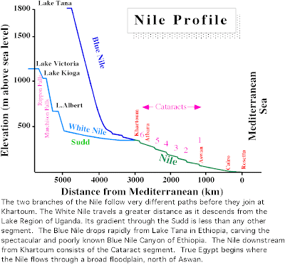
The Nile consists of two principal branches - the White Nile and the Blue Nile - which join at Khartoum to form the main Nile. The main Nile consists of the Egyptian Nile and the Cataract Nile. The White Nile, which is the longest segment, may be further subdivided into: 1) The Central Sudan region; 2) The Sudd; and 3) the Lake Plateau region.

Nile-How is ti compared with other rivers?
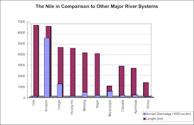
In spite of its great length and large drainage basin (3,000,000 km2, or about 10% of Africa, and affecting 9 nations), it carriers relatively little water. Yearly flows over the past century ranged from a low of 42 km3 in the drought year of 1984 to a high of 120 km3 for 1916. This relatively low flow for such a long river is because no water is added to it north of its confluence with the Atbara River, and much is lost by evaporation. Most other great rivers join with other large streams as they approach the sea, joining their waters into an ever-swelling stream. Instead, the Nile wanders through the largest and most arid region on earth, the Sahara Desert.

Nile-Where is it?
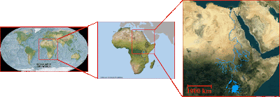
The Nile is the great river of northeast Africa. It begins in well-watered regions near the equator and flows northward across the terrible Sahara Desert before it empties into the eastern Mediterranean Sea. It is 6825 km or 4100 miles long and is the longest river on earth. Only the Amazon River of South America rivals the length ofthe Nile. Both the source of the White Nile in Equatorial Africa and its mouth on the southern shore of the Mediterranean Sea lie within one degree of longitude. It crosses 35 degrees of latitude, a distance comparable to the width of the continental United States, and flows across regions which differ more from each other than lands drained by any other river.

Friday, October 17, 2008
The History
6 MILLION BCE: The earliest we know of a river through Egypt; scientists name it Eonile. This river ran through a canyon with walls that could be up to 3,000 metres high. There are indications that the Mediterranean Sea did not exist in this period. The source of Eonile is not known.
5 MILLION: The waters of the Mediterranean Sea rises, filling up a basin reaching as far as modern Aswan. This brings an end to Eonile.
4 MILLION: A second river starts flowing through Egypt, by modern scholars referred to as Paleonile. Its sources are believed to have been in equatorial Africa.
1.8 MILLION: Dramatic climatic changes, causing the end of a water stream flowing north. Desertification in North Africa casues the emoty river canal to be filled with sand.
1.5 MILLOIN: The third river, the Protonile, starts flowing through Egypt, creating many interwoven channels. The Protonile ran to the west of the modern Nile, through the region known today as Western Desert.
500,000: The Prenile replaces the Protonile, running further to the east, and starts carving out the river valley existing today. Its discharge was the largest ever for any of the Niles, before and since.
150,000 The Prenile starts to dry out.
30,000: The Neonile starts flowing through Egypt, basically following the same course as the modern Nile, but with a higher elevation.
8,000: The Neonile has carved itself down to the present elevation, and we can start talking about the Nile as we know it today.
1902: The Aswan Dam opens, allowing better control with the flow and flooding of the Nile through Egypt.
1960: The Aswan High Dam opens, allowing Egypt even better control with the flow all through the year, but removing the valuable silt which normally enriched the soil. A very important hydroelectric power plant is constructed here.
Blue and white nile is the river nile coloured?
The River has the nickname of the White river but it is not really white, it is clear, and has fast moving waters so it may look white but the real color of the water is clear, it has no color, no water does, it just hass the reflection of the sky, so it looks blue, or white, like you said.
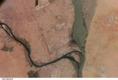
The Blue Nile (left), White Nile (right), merge near Khartoum, Sudan.

The Blue Nile (left), White Nile (right), merge near Khartoum, Sudan.
Will Nile dry up..............What can we do to stop it?
Most of the water resources goes towards farming. Already the Colorado River in the US and the Yellow River in China no longer make it to the sea. (this is what they mean when they say the Nile will run dry... we divert more and more water, taking it away from ecosystems downstream.)
Conservation helps, but better farming irrigation techniques and eating less meat is crucial as the world population continues to grow exponentially. 70% of all fresh water goes to farming and the majority of the produce goes to feed livestock! The UN recently did a report on water resources and they estimated that for every 1 lb of beef it takes 7 lbs. of feed grain, which takes 7,000 lbs. of water to grow. The water that goes to make the corn could used to feed more people with 7 lbs of vegetables and beans than 1 lb of steak. This is not to say that we all must become vegans, but if we all ate one less meal with meat a week it would make a tremendous difference! "Pass up one hamburger, and you'll save as much water as you save by taking 40 showers with a low-flow nozzle."
Conservation helps, but better farming irrigation techniques and eating less meat is crucial as the world population continues to grow exponentially. 70% of all fresh water goes to farming and the majority of the produce goes to feed livestock! The UN recently did a report on water resources and they estimated that for every 1 lb of beef it takes 7 lbs. of feed grain, which takes 7,000 lbs. of water to grow. The water that goes to make the corn could used to feed more people with 7 lbs of vegetables and beans than 1 lb of steak. This is not to say that we all must become vegans, but if we all ate one less meal with meat a week it would make a tremendous difference! "Pass up one hamburger, and you'll save as much water as you save by taking 40 showers with a low-flow nozzle."
Facts..........Must read
Length: (From White Nile Source to Mouth) 6695km (4184 miles).
Name: The Nile gets its name from the Greek word "Nelios", meaning River Valley.
Sources: The White Nile: Lake Victoria, Uganda. The Blue Nile: Lake Tana, Ethiopia.
Countries: The Nile and its tributaries flow though nine countries. The White Nile flows though Uganda, Sudan, and Egypt. The Blue Nile starts in Ethiopia. Zaire, Kenya, Tanzanian, Rwanda, and Burundi all have tributaries, which flow into the Nile or into lake Victoria Nyanes.
Cities: The major cities that are located on the edge of the Nile and White Nile are: Cairo, Gondokoro, Khartoum, Aswan, Thebes/Luxor, Karnak, and the town of Alexandria lies near the Rozeta branch.
Major Dams: The major dams on the Nile are Roseires Dam, Sennar Dam, Aswan High Dam, and Owen Falls Dam.
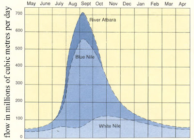
Flow Rate: The Nile River's average discharge is about 300 million cubic metres per day. To get a more accurate idea about how much water actually flows in the nile look at this image:
Name: The Nile gets its name from the Greek word "Nelios", meaning River Valley.
Sources: The White Nile: Lake Victoria, Uganda. The Blue Nile: Lake Tana, Ethiopia.
Countries: The Nile and its tributaries flow though nine countries. The White Nile flows though Uganda, Sudan, and Egypt. The Blue Nile starts in Ethiopia. Zaire, Kenya, Tanzanian, Rwanda, and Burundi all have tributaries, which flow into the Nile or into lake Victoria Nyanes.
Cities: The major cities that are located on the edge of the Nile and White Nile are: Cairo, Gondokoro, Khartoum, Aswan, Thebes/Luxor, Karnak, and the town of Alexandria lies near the Rozeta branch.
Major Dams: The major dams on the Nile are Roseires Dam, Sennar Dam, Aswan High Dam, and Owen Falls Dam.
Flow Rate: The Nile River's average discharge is about 300 million cubic metres per day. To get a more accurate idea about how much water actually flows in the nile look at this image:


Subscribe to:
Posts (Atom)